Abstract: This study quantifies the economic and environmental costs associated with public transport deficits in Jizzakh, Uzbekistan, through GIS spatial analysis, a resident survey, and quantitative modelling. Using QGIS software, pedestrian accessibility zones (400 m) were generated across five neighbourhoods in accordance with Uzbekistan’s urban standards (ShNQ 2.07.01-03). Spatial analysis reveals that peripheral neighbourhoods record transport coverage of only 10–24%, against 80% in the reference area, confirming a radially biased network. A survey indicates that 60% of peripheral residents are compelled to use private transport. The total daily travel distance in the study area is estimated at 95,890 km. At operating costs of €0.203/km, this represents a daily economic burden of approximately €19,464 (€4.87 million annually). CO₂ emissions from this forced dependence are estimated at 9.6–11.5 tonnes per day. The results demonstrate that structural deficits in public transport coverage create quantifiable costs at the neighbourhood level. The study provides empirical evidence from a post-Soviet urban context and presents a methodological framework applicable to comparable secondary cities in Central Asia.
Keywords: public transport accessibility, GIS analysis, QGIS, forced private transport, CO₂ emissions, economic cost, Jizzakh, Uzbekistan, secondary cities, urban mobility
EKONOMICKÉ A ENVIRONMENTÁLNE NÁKLADY DEFICITOV VEREJNEJ DOPRAVY V SEKUNDÁRNOM MESTE: DÔKAZY Z JIZZAKHU, UZBEKISTAN
Abstrakt: Táto štúdia kvantifikuje ekonomické a environmentálne náklady spojené s nedostatkami verejnej dopravy v meste Jizzakh v Uzbekistane prostredníctvom GIS analýzy, prieskumu medzi obyvateľmi a kvantitatívneho modelovania. Pomocou softvéru QGIS boli vytvorené pešie dostupnostné zóny (400 m) v piatich štvrtiach v súlade s normami Uzbekistanu (ShNQ 2.07.01-03). Priestorová analýza ukazuje, že periférne štvrte dosahujú pokrytie len 10–24 %, zatiaľ čo referenčná štvrť Jilliquli 80 %, čo potvrdzuje radiálne orientovanú sieť. Prieskum medzi 100 respondentmi naznačuje, že 60 % obyvateľov periférií je nútených využívať súkromnú dopravu. Celková denná vzdialenosť v skúmanej oblasti sa odhaduje na 95 890 km obojsmerne. Pri prevádzkových nákladoch 0,203 €/km to predstavuje dennú ekonomickú záťaž približne 19 464 € (4,87 mil. € ročne). Emisie CO₂ spôsobené touto závislosťou sa odhadujú na 9,6–11,5 tony denne (faktor 100–120 g CO₂/km). Výsledky dokazujú, že štrukturálne nedostatky v pokrytí verejnou dopravou vytvárajú merateľné náklady na úrovni štvrtí. Štúdia prináša empirické dôkazy z postsovietskeho urbanistického kontextu a predstavuje metodologický rámec aplikovateľný na porovnateľné sekundárne mestá v Strednej Ázii.
Kľúčové slová: dostupnosť verejnej dopravy, GIS analýza, QGIS, nútené využívanie súkromnej dopravy, emisie CO₂, ekonomické náklady, Jizzach, Uzbekistan, sekundárne mestá, mestská mobilita
JEL: R41, Q53, R52
1 Introduction
In the context of modern urbanization, the efficient organisation of public transport systems plays a crucial role in ensuring sustainable urban development, economic growth, and environmental sustainability. However, in many developing cities, including Jizzakh, the predominantly radial structure of the transport network-primarily oriented toward the city center-creates imbalances in connectivity between peripheral areas and the urban core.
This study aims to identify existing shortcomings in the public transport network of Jizzakh city through digital analysis using QGIS software. The overall transport network and route system of Jizzakh city are illustrated in Picture 1.
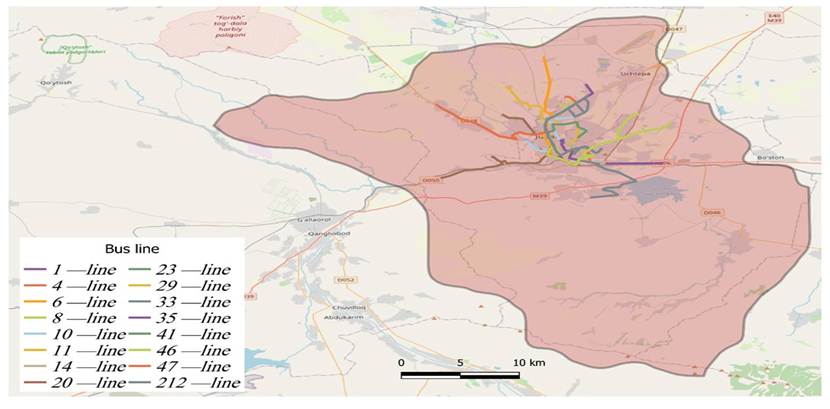
Source: Author’s own processing using QGIS
Picture 1. Public transport network map of Jizzakh city.
The results of the analysis indicate that although transport routes have a high density in the city center, lateral connectivity in peripheral areas remains insufficiently developed. This situation reduces public trust in public transport and compels residents to rely on private vehicles. The objective of this study is to evaluate public transport coverage within five specifically selected neighbourhoods: Kuyovboshi, To‘qchilik, Jilliquli, Sayhon, and Hamzaobod. These areas were chosen as representative case studies due to their peripheral location, low public transport density, and high dependence on private mobility, which reflect the typical infrastructure challenges faced by the city’s outskirts. Furthermore, the study aims to quantify the economic costs and the volume of CO₂ emissions resulting from this forced reliance on private transport. The findings serve as a strategic basis for developing recommendations to optimize the urban transport network, enhance accessibility, and mitigate environmental impact.
2 Literature Review
The international literature on urban public transport accessibility and its socioeconomic consequences has expanded considerably over recent decades, demonstrating multifaceted effects on population welfare, environmental conditions, and urban spatial development. However, the geographic scope of existing research remains uneven, with scholarly work concentrated predominantly in Western Europe, North America, and major Asian metropolitan centres. Secondary cities in Central Asia – and Uzbekistan in particular – remain significantly understudied in international transport research.
2.1 Public Transport Accessibility and Urban Equity
Public transport accessibility has long been recognised as a fundamental determinant of urban equity and social inclusion. Rodrigue (2020) argues that the spatial organisation of transport networks directly shapes residents’ ability to access employment, education, and healthcare – with peripheral urban populations bearing a disproportionate burden when networks are radially structured and centre-oriented [1]. Newman and Kenworthy (2015) further demonstrate, through longitudinal analysis of 44 global cities, that automobile dependence is not an inevitable outcome of urbanization but rather a product of specific planning decisions that prioritise road infrastructure over integrated public transit [2]. Their work establishes a clear inverse relationship between public transport network quality and per-capita private vehicle use [2], providing a theoretical foundation for the present study’s hypothesis that expanding coverage in Jizzakh’s peripheral neighbourhoods would reduce forced private transport dependency. In the context of developing and transitioning economies, this relationship is amplified by the relative unaffordability of private vehicle ownership, making public transport access a matter of economic necessity rather than preference for a significant share of the urban population.
2.2 Forced private transport in Developing Cities
In cities where formal public transport networks fail to meet spatial demands, residents consistently develop informal mobility arrangements to fill the gaps. Paratransit modes have long tended to fill the void left by formal systems, particularly in peripheral urban areas where formal transport is absent or inadequate [3]. In developing countries, these systems remain demand-driven and user-oriented, characterized by high operational flexibility, easy market entry, and small vehicles under limited formal oversight – features that persist across developing-country contexts regardless of region or income level [4]. The distinction between voluntary ridesharing and forced private transport – where residents share vehicles not by preference but due to the absence of viable alternatives – is directly relevant to the present study. The observed occupancy rate of 3.0 passengers per vehicle in Jizzakh’s peripheral neighbourhoods reflects a rational collective response to unmet mobility demand, consistent with established patterns of informal vehicle sharing in urbanizing contexts with fragmented formal networks.
2.3 Economic and Environmental Costs of Private Transport Dependency
Private transport dependency imposes significant economic burdens in developing cities. Studies show that in cities with public transport coverage below 30%, household transport costs typically account for 15–25% of total income, disproportionately affecting low-income peripheral residents [5]. From an environmental perspective, higher public transport shares are strongly associated with lower CO₂ emissions. Newman and Kenworthy (2015) report that shifting from private cars to public transport can reduce emissions by 60–80% per passenger-kilometre [2]. Uzbekistan has committed to reducing greenhouse gas emissions by 35% by 2030 compared to 2010 levels, with the transport sector playing a key role in achieving this target. This study provides empirical evidence on the economic costs and CO₂ emissions resulting from inadequate public transport coverage in a secondary city context.
2.4 Research Gap and Study Contribution
Despite the substantial body of literature on urban public transport accessibility, informal mobility, and transport-related emissions, secondary cities in Central Asia – and Uzbekistan in particular – remain severely underrepresented in the international transport research literature. The majority of existing studies focus on large metropolitan areas in Western Europe, North America, or major Asian cities, leaving a significant empirical gap in the understanding of transport dynamics in post-Soviet urbanizing contexts. Here, post-Soviet urban context refers to the Soviet-era planning legacy still shaping Jizzakh: a radial, centrally-oriented street network, residential development organised into self-contained micro-districts (mikrorayons) with limited lateral connectivity, and centralised transport provision not yet adapted to post-independence peripheral growth and rising private vehicle ownership. Jizzakh, as a mid-sized regional center with a predominantly radial transport network and rapidly growing peripheral neighbourhoods, exemplifies the structural challenges faced by a large class of cities across Central Asia and the broader developing world. By combining GIS-based spatial analysis, resident survey data, and quantitative economic and environmental modelling, the present study addresses this gap and provides a replicable methodological framework applicable to comparable urban contexts across the region.
3 Methodology
In this study, the public transport coverage of Jizzakh city and its economic and environmental impacts were examined using an interdisciplinary approach. The methodology consists of three main stages: GIS analysis, a social survey, and quantitative modeling.
The public transport network was digitized and mapped using QGIS software. Based on the coordinates of all existing bus stops within the city, pedestrian accessibility zones (buffer zones) with a radius of 400 meters were generated. This distance is aligned with both international best practices in transit planning and Uzbekistan’s national urban planning standards, which specify a maximum walking distance of 400 metres to the nearest public transport stop [6, 7]. All bus lines operate at a uniform scheduled headway of approximately 10 minutes, with no variation by route or neighbourhood, so the coverage disparities reported below reflect route/stop placement rather than service frequency. The selection of the five study neighbourhoods – Kuyovboshi, To’qchilik, Jilliquli, Sayhon, and Hamzaobod – was based on the results of the preliminary GIS-based buffer zone analysis conducted across the entire administrative territory of Jizzakh city. Following the generation of 400-metre pedestrian catchment zones around all existing bus stops, it became evident that a substantial proportion of the city’s peripheral neighbourhoods fell outside the effective coverage of the public transport network. From among these underserved areas, four neighbourhoods – Kuyovboshi, To’qchilik, Sayhon, and Hamzaobod – were purposively selected as representative cases of low to critically insufficient public transport coverage (10-24%; see Picture 2). In addition, Jilliquli neighbourhood was included as a comparative reference case, representing an area with relatively high coverage (80%). This deliberate contrast between predominantly unserved and adequately served neighbourhoods enables a systematic comparative analysis of the relationship between public transport accessibility levels and residents’ mobility behaviour, private transport dependency, and associated economic and environmental costs.
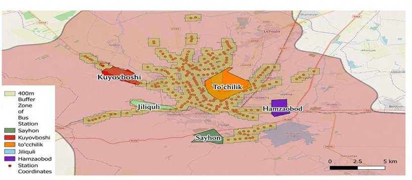
Source: Author’s own processing using QGIS
Picture 2. Analysis of bus stop coverage and resident survey zone.
Within the framework of this scientific study, a structured pilot survey was conducted among 100 randomly selected residents (20 from each of the five target neighbourhoods: Kuyovboshi, To‘qchilik, Jilliquli, Sayhon, and Hamzaobod). Each respondent reported their own transport choice individually; the dataset is therefore individual-level, not household-level, hence the term “resident survey” used throughout. The survey, distributed via Google Forms, examined residents’ transport choices and the specific reasons behind their mobility preferences. Although this represents a targeted sample, it serves as a preliminary assessment to identify critical trends and validate the research methodology within Jizzakh’s urban context. The findings highlight the primary factors influencing respondents’ preference for private transport, as illustrated in the following Picture 3.
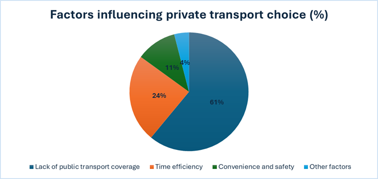
Source: Author’s own survey data (2026)
Picture 3. Factors influencing private transport choice (%)
Per-kilometer operating costs were estimated by combining locally sourced fuel price data with a cost multiplier of 2.5 to account for vehicle maintenance and depreciation, consistent with the cost framework applied to developing-country private transport contexts by Cervero & Golub (2007) [12] and supported by ITF (2023) [5] estimates for household transport expenditure in cities with low public transport coverage. The forced private transport occupancy rate of 3.0 passengers per vehicle was derived from survey responses and used as the basis for vehicle-trip estimation. The two core formulas applied are:

(2) Total kilometers = number of vehicles × distance to city center (2)
This study tests two hypotheses in Section 4.1: H1: PT coverage is negatively associated with forced private transport share. H2: The radial network produces a measurable coverage gap between peripheral and centrally-served neighbourhoods, independent of population size.
4. Results
This section presents the findings of the three-stage analysis in sequence: GIS-based spatial coverage assessment, resident survey results, and quantitative modelling of economic and environmental costs.
4.1. Spatial Coverage Analysis (GIS)
Buffer zone analysis using QGIS software revealed a pronounced spatial imbalance in public transport (PT) coverage across the five study neighbourhoods. Table 1 summarises population, daily commuter volumes, and the share of each neighbourhood falling within the 400-metre pedestrian catchment zone of an existing bus stop.
Table 1. Population and public transport coverage by neighbourhood
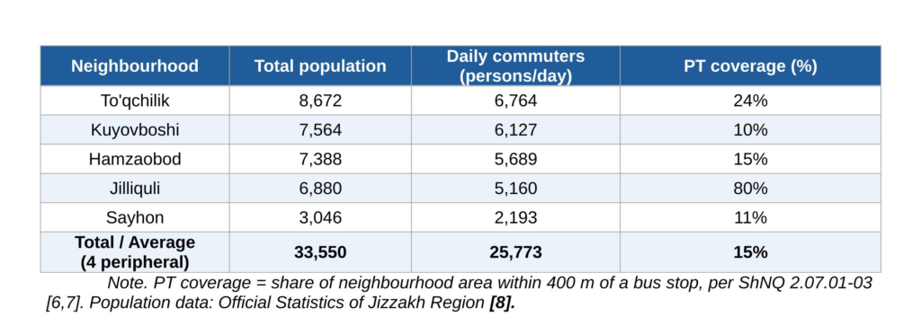
The four peripheral neighbourhoods (Toʼqchilik, Kuyovboshi, Hamzaobod, Sayhon) recorded PT coverage levels of 10-24%, with a weighted average of approximately 15%. In contrast, Jilliquli – the reference neighbourhood – exhibited 80% coverage. These findings confirm that the existing network is radially structured and heavily concentrated in the city center, leaving the majority of peripheral residents outside effective PT reach.
4.2 Resident Survey Results
The minimum required sample size was determined using the Cochran (1977) formula for unknown populations:
n = Z² × p × (1−p) /e² (3)
where Z = 1.96 (95% confidence level), p = 0.5 (maximum variance assumed due to lack of prior distributional data), and e = 0.10 (acceptable margin of error for a pilot study). Substituting these values yields a minimum sample size of n ≈ 97 respondents. Accordingly, a total of 100 residents were surveyed across five neighbourhood [9] (20 per neighbourhood), satisfying the statistically required threshold. While the authors acknowledge this as a pilot-scale study, the sample size is statistically justified for exploratory urban transport research in a secondary city context [10].
A pilot survey of 100 residents (20 per neighbourhood) revealed high rates of forced private transport dependency in the four underserved areas. Survey responses indicated that approximately 60% of respondents in peripheral neighbourhoods cited the absence of a nearby bus stop as their primary reason for using private transport, while 24% reported time savings as the main motivator (Picture 3). In the reference neighbourhood of Jilliquli, only 25% of daily commuters relied on private transport. Table 2 presents the estimated modal split applied to the full daily commuter population.
Table 2. Daily commuters and estimated private transport users by neighbourhood
Aggregating across the five neighbourhoods, the pooled private transport share is approximately 72.5% (18,806 of 25,933 commuters), with the remaining 27.5% using public transport or other modes. This reflects only the sampled study area, not a city-wide modal split, which is not currently published for Jizzakh (see Section 6). A Pearson correlation between PT coverage (Table 1) and private transport share (Table 2) yields r = -0.99 (p < 0.001, n = 5), strongly supporting H1; given the small number of spatial units, this should be read as suggestive rather than statistically conclusive, pending replication across a larger sample of neighbourhoods.
4.3 Daily Travel Distance
Based on the forced private transport occupancy rate of 3.0 passengers per vehicle, the number of vehicle trips and total daily kilometers were calculated for each neighbourhood. Table 3 presents the disaggregated results.
Table 3. Estimated daily vehicle trips and total travel distance by neighbourhood
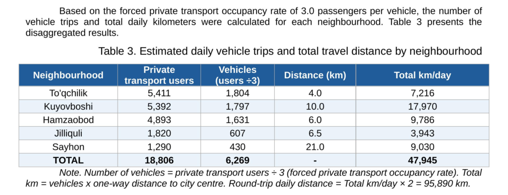
Note. Number of vehicles = private transport users ÷ 3 (forced private transport occupancy rate). Total km = vehicles x one-way distance to city centre. Round-trip daily distance = Total km/day × 2 = 95,890 km.
The combined daily travel distance across all five study neighbourhoods amounts to 95,890 km, with Kuyovboshi accounting for the largest share (35,940 km/day) due to the highest number of private transport users and the greatest distance from the city center (10.0 km).
4.4 Economic Cost Estimation
Per-kilometer operating costs were estimated using locally sourced price data. Table 4 presents the detailed cost breakdown.
Table 4. Estimation of per-kilometer private transport operating cost in Jizzakh (2026)
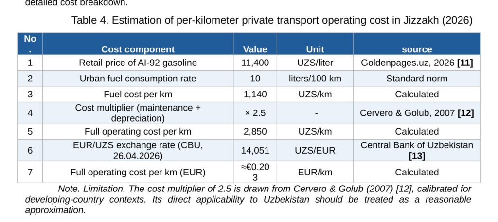
Applying the estimated full operating cost of €0.203 per km to the round-trip daily distance of 95,890 km yields a daily economic cost of approximately €19,464 (≈ 273,543,720 UZS). On an annualised basis (250 working days), this equates to approximately €4.87 million per year attributable to inadequate PT coverage in the five study neighbourhoods.
4.5 Environmental Impact: CO₂ Emissions
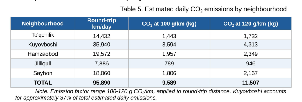
CO₂ emissions from private vehicle trips were estimated using an emission factor range of 100-120 g CO₂ per km for petrol-powered passenger cars. Applying this range to the total round-trip daily distance of 95,890 km yields estimated daily emissions of 9.6–11.5 tonnes of CO₂ from the five study neighbourhoods. Table 5 presents the emissions breakdown by neighbourhood.
Table 5. Estimated daily CO₂ emissions by neighbourhood
4.6 Summary of Key Findings
The three-stage analysis consistently identifies a systemic deficit in public transport coverage in Jizzakh’s peripheral neighbourhoods. The principal quantitative findings are: (1) PT coverage in the four peripheral neighbourhoods averages 15%, compared to 80% in Jilliquli; (2) approximately 60% of surveyed peripheral residents are compelled to use private transport; (3) total one-way daily travel distance is 47,945 km (95,890 km round-trip); (4) the associated daily economic cost is approximately €19,464 (≈273.5 million UZS), equivalent to €4.87 million per year; and (5) daily CO₂ emissions are estimated at 9.6–11.5 tonnes, with Kuyovboshi accounting for 37% of the total.
5 Discussion
The findings confirm that Jizzakh’s public transport network exhibits a strongly centralized, radial structure, systematically disadvantaging peripheral residents – a pattern consistent with comparable developing-country cities [1, 2]. In the studied neighbourhoods, public transport coverage falls below 20%, compelling approximately 60% of residents to rely on private vehicles or informal taxi services. The recorded forced private transport occupancy rate of 3.0 passengers per vehicle reflects demand-driven self-organisation under conditions of inadequate formal provision [9, 4]. Public transport is widely recognised as one of the most cost-effective solutions to urban climate and mobility challenges, with buses and trains capable of reducing greenhouse gas emissions by up to two-thirds per passenger-kilometer compared to private vehicles [14]. Against this benchmark, the estimated daily CO₂ output of 9.6–11.5 tonnes from five peripheral neighbourhoods illustrates the tangible environmental cost of inadequate coverage [5]. For Uzbekistan specifically, the ITF’s decarbonization pathways study identifies a shift toward low-carbon, integrated public transport as the central policy lever for reducing urban transport emissions through 2050 [15].
The high rates of forced private transport dependency – reaching 88% in Kuyovboshi neighbourhood – reflect a global urbanization trend particularly pronounced in developing countries, where urban sprawl has contributed to rising vehicle ownership and negative externalities including congestion and emissions [17]. In the Uzbekistan context, this is reinforced by Nishonov et al. (2025), who document that the total number of privately owned vehicles reached 4,020,744 units by 2024 at an average annual growth rate of 7.5% [6], making the present study’s neighbourhood-level findings a microcosm of a structural challenge operating at the national scale.
6 Limitations
Several limitations of this study should be acknowledged. First, the resident survey was conducted on a pilot scale, with 100 respondents across five neighbourhoods (20 per neighbourhood). Although statistically justified using the Cochran (1977) formula for exploratory research, the sample size limits the generalisability of the modal split estimates to the broader population of Jizzakh city.
Second, the study covers five selected neighbourhoods and does not represent the full spatial extent of Jizzakh city. Neighbourhoods not included in the study may exhibit different patterns of transport dependency and coverage.
Third, CO₂ emission estimates are based on a standard petrol passenger car emission factor and do not account for vehicle age, engine condition, or the presence of older, higher-emission vehicles that are common in Uzbekistan’s vehicle fleet -factors that could result in higher actual emissions than reported here.
Fourth, a published city-wide modal split for Jizzakh is not available; the pooled modal split in Section 4.2 is restricted to the five study neighbourhoods and should not be extrapolated city-wide.
7 Recommendations
Based on the study findings, the following measures are recommended for the strategic development of Jizzakh’s urban transport system. First, new lateral route connections between peripheral neighbourhoods should be introduced as a priority. The current radial structure does not serve cross-neighbourhood mobility demand, and targeted lateral lines would substantially reduce forced private transport dependency [2]. Second, bus stop placement should be reorganized so that all residential areas fall within the 400-metre pedestrian catchment zone in line with national ShNQ standards [6-7]. Third, the integration of Intelligent Transport Systems – including real-time passenger flow monitoring, dynamic route adjustment, and digital demand mapping – would enable evidence-based network optimization and improve long-term service efficiency [16]. Fourth, existing informal shared mobility arrangements should receive regulatory recognition as a transitional measure, given their demonstrated role in filling formal transport gaps [9, 4]. Fifth, the findings of this study should inform a broader regional transport planning framework applicable to comparable secondary cities across Uzbekistan and Central Asia [14].
8 Conclusion
This study provides empirical evidence that inadequate public transport coverage in Jizzakh’s peripheral neighbourhoods generates substantial and quantifiable economic and environmental costs. GIS-based spatial analysis confirms a structural imbalance in the existing network, while survey data demonstrates the direct behavioural consequences – including high rates of forced private transport use and informal vehicle sharing [9, 4]. The estimated daily economic loss of €19,464 (round-trip basis) and CO₂ emissions of 9.6–11.5 tonnes underscore the urgency of targeted infrastructure investment. The integration of ITS technologies has demonstrated measurable improvements in public transport efficiency across diverse urban contexts and represents a viable pathway for secondary cities undergoing network reform [16]. Expanding public transport coverage, introducing lateral route connections, and deploying ITS represent the principal pathways toward a more equitable and sustainable urban mobility system in Jizzakh. The methodological framework applied – combining GIS analysis, resident survey data, and quantitative modelling – is replicable across comparable secondary cities in Central Asia and the broader developing world [15].
9 Data Availability
The survey dataset supporting the findings of this study is openly available on Zenodo at https://doi.org/10.5281/zenodo.19799747
10 References
[1] RODRIGUE, J.P. The Geography of Transport Systems. 4. vyd. New York: Routledge, 2020.
[2] NEWMAN, P. – KENWORTHY, J. The End of Automobile Dependence: How Cities Are Moving Beyond Car-Based Planning. Washington: Island Press, 2015.
[3] BHUYAN, I.A. – ROY, S.K. The Role of Paratransit in Sustainable Urban Mobility: A Scoping Review. In Research in Transportation Economics [online]. 2025. Vol. 113, 101396. [cit. 2026-04-26]. DOI: 10.1016/j.retrec.2025.101396
[4] DZISI, E.K. et al. Paratransit in the Digital Era: A Comparative Systematic Literature Review. In Research in Transportation Business & Management . 2025. [cit. 2026-04-26]. DOI: 10.1016/j.rtbm.2025.101213
[5] INTERNATIONAL TRANSPORT FORUM. Transport Outlook 2023. Paris: OECD/ITF, 2023.
[6] NISHONOV, A. – ABDUNAZAROV, J. – SHAUMAROV, S. – YUSUPOV, U. – ERGASHEV, A. – KADIROV, Y. et al. The current state and challenges of population mobility in the Republic of Uzbekistan. In Smart Cities and Advanced Technologies . 2025. [cit. 2026-04-26]. DOI: 10.21595/scat.2025.25816
[7] ShNQ 2.07.01-03. Town Planning. Planning and Development of Urban and Rural Settlements. Tashkent, 2003.
[8] NATIONAL STATISTICS COMMITTEE OF THE REPUBLIC OF UZBEKISTAN [online]. Tashkent. . Available from: https://stat.uz/uz/
[9] ERGASHEV, A. Survey data: Economic and Environmental Costs of Public Transport Deficits in Jizzakh, Uzbekistan [dataset, online]. Zenodo, 2026. . Available from: https://doi.org/10.5281/zenodo.19799747
[10] COCHRAN, W.G. Sampling Techniques. 3. vyd. New York: John Wiley & Sons, 1977.
[11] GOLDENPAGES.UZ. Gasoline prices at fuel stations in Uzbekistan, April 2026 . 2026. [cit. 2026-04-26]. Available from: https://www.goldenpages.uz/en/benzin-cena/
[12] CERVERO, R. – GOLUB, A. Informal transport: A global perspective. In Transport Policy [online]. 2007. Vol. 14, no. 6, s. 445-457. [cit. 2026-04-26]. DOI: 10.1016/j.tranpol.2007.04.011
[13] CENTRAL BANK OF THE REPUBLIC OF UZBEKISTAN. Official EUR/UZS exchange rate, April 26, 2026 [online]. 2026. [cit. 2026-04-26]. Available from: https://cbu.uz/en/
[14] WELLE, B. – KUSTAR, A. – TUN, T.H. – ALBUQUERQUE, C. The Current State of Public Transport as a Climate Solution [online]. Washington: World Resources Institute, 2023. [cit. 2026-04-26]. Available from: https://www.wri.org/insights/current-state-of-public-transport-climate-goals
[15] INTERNATIONAL TRANSPORT FORUM. Decarbonising Pathways for Urban Mobility in Uzbekistan [online]. Paris: OECD/ITF, 2023. [cit. 2026-04-26]. Available from: https://www.itf-oecd.org/decarbonising-pathways-urban-mobility-uzbekistan
[16] ADENIRAN, A.O. et al. Adoption of Intelligent Transport Systems (ITS) in Urban Transportation Planning. In Discover Global Society [online]. 2025. . DOI: 10.1007/s44282-025-00312-3
[17] SOGBE, E. – SUSILAWATI, S. – PIN, T.C. Scaling up public transport usage: A systematic literature review. In Public Transport [online]. 2024. [cit. 2026-04-26]. DOI: 10.1007/s12469-024-00367-6
Acknowledgement
The contribution was elaborated with the support of the Ministry of Education, Research, Development and Youth of the Slovak Republic: VEGA no. 1/0606/25 Konečný, V.: Research on positive externalities from road transport services in the context of quality improvement and performance evaluation.
Autori:
Azizbek ERGASHEV ¹, Miroslava MIKUŠOVÁ ²
Tituly a pôsobisko autorov:
1 Azizbek Ergashev (Bc.), Jizzakh Polytechnic Institute, Islom Karimov Avenue 4, 130100 Jizzakh, Uzbekistan; and výmenný študent Žilinská univerzita v Žiline, Univerzitná 8215/1, 010 26 Žilina, Slovenská republika. E-mail: ergashevazizbek019@gmail.com
² Ing. Miroslava MIKUŠOVÁ, PhD., Katedra cestnej a mestskej dopravy, Fakulta prevádzky a ekonomiky dopravy a spojov, Žilinská univerzita v Žiline, Univerzitná 8215/1, 010 26 Žilina, Slovenská republika. E-mail: miroslava.mikusova@uniza.sk
