The problem of data transmission is gaining increasing significance in rail transport. This sector of transport used to apply pioneer solutions, such as telegraphy; however, over the years modern technologies gave the railway (Poland) a wide berth. Nowadays, as more and more equipment used in the railway includes electronic and computer devices, it may be claimed that modernity in the railway is making a comeback. Digital and computer science technologies exist not only in processes associated with control (traffic, rolling stock, power engineering) and diagnostics (DSAT systems, monitoring, etc.), but also in services associated with exchange of information on trains or commercial aspects. Information flow technologies in computer networks are the domain of telematics. The term, introduced by the International Consultative Committee on Telephony and Telegraphy, is a combination of telecommunications and informatics. Telematics, viewed as a science, integrates research in telecommunications, control engineering and computer science.
The term telematics derives from French and was introduced in literature at the end of 1970s. Since 1980, this term has been appearing in English vocabulary as well. The currently used term is defined as telecommunication, computer science and information solutions, as well as automated control solutions, all adjusted to the requirements of operated physical systems; the solutions are often integrated with such systems. The scope of telematics includes receiving, transmitting and processing data, but also transmitting such data (to the user or an actuation device) so that a given task can be automated.
In recent years, the term telematics can be found in various sectors of the economy such as financial telematics, medical telematics, and transport telematics, etc.
Telematics is a relatively new term in Poland. The concept of transport telematics appeared in Poland in the mid-1990s, when an attempt was made to determine its conceptual scope and applicability. Telematics embraces the use of computer devices and telecommunication equipment, as well as their software.
It is difficult to imagine that the modern railway would function without telematics, although it is not often referred to by its real name. This applies to both companies of the Polish National Railways, as well as manufacturers of equipment and systems for railway applications. Telematics ensures efficient traffic management and improves safety and effectiveness of passenger and goods transport.
Railway transport telematics is based on the development of a new generation of technical measures, in particular the European Rail Traffic Management System (ERTMS) and the Global System for Mobile Communications – Rail (GSM-R). An essential objective of telematics is to facilitate railway traffic control and integrate information and communication systems that ensure safety of train traffic.
Telematics in control of rail vehicles, is based on human-machine interface developed for the train driver, facilitates operation and improves effectiveness of control, while the risk of human error can be reduced. It can also aid location of a train along the route.
Further, the list should include equipment for detecting failure statuses in the rolling stock or a group of devices that can detect, in particular, overheated axles, overheated brakes, deformed wheel tread, overloaded railway cars, unevenly distributed wheel pressure forces, and exceeded gauge limit.
Development of satellite navigation systems and introduction of GDM-R in the railway have offered new possibilities in management and control of railway traffic. It allows for the development of new applications and projects in this scope. By combining systems such as GPS and GSM (not necessarily GSM-R) it is possible to create advanced systems for transmitting information for passengers, execute supervision over the rolling stock, as well as for monitoring the stock.
The occurrence and development of safe GNSS services, mainly due to the future satellite navigation system being created now in Europe, i.e. GALILEO, can improve competitiveness on many railway lines in Poland.
Besides the planned expansion of satellite navigation services, wireless telecommunications is the second faster developing field worldwide. New approaches to European railways (interoperability, liberalization), creation of interdisciplinary pan-European projects of systems with the use of data radio transmission (ETCS) necessitate changes in railway radio communications. In addition, integration processes are in their heyday. The European Union and other supernational organizations are expanding and have devised further expansion plans. In such high-speed times, the problem of standardizing technical solutions applied in the railway so that country borders are not noticeable for trains, is gaining more and more significance. The lack of standards relating to train operation, including a standard of train-purpose radio communications, can be an obstacle in creating safe international high-speed transport. The decision to accept GSM as a base for the future radio communication standard in the International Union of Railways (UIC) was a result of comprehensive research. This research has confirmed that the system can be put into operation in the railway conditions and the fact that practically all railway services can be integrated into the existing GSM system architecture.
GSM-R allows for avoiding disadvantages of analogue solutions by offering their subscribers services integrated analogically to ISDN, including all benefits for the subscriber resulting from being mobile around the entire Europe. Moreover, GSMR allows for increasing flexibility in designing services associated with radio communications, and ultimately, reducing costs of maintaining radio networks in managing entities which use various radio frequency ranges.
This paper discusses the application of GPS and GSM in management and control of railway traffic.
1 The INTEGRAIL project
The use of GNSS to locate a train under ETCS specifications was the main aim of a series of projects, carried out by the European Union and the European Space Agency, such as INTEGRAIL and GADEROS.
The main objective of the project was to devise a low-cost hardware and software platform for a hybrid train location system with the use of data combined from sources such as:
- GPS/EGNOS systems, and also
- odometer,
- angular velocity meter,
- digital route map,
- accelerometer,
- digital compass.
Another objective of the project was to use such positioning methods in applications associated with the process of railway traffic management, as well as safety applications for controlling railway traffic.
In addition, the project was also aimed at creating a mobile module, functioning as a train positioning subsystem that would be compatible functionally with location and speed measuring equipment listed and detailed in ETCS specifications to enable integration of positioning based on GNSS-I with ERTMS/ETCS.
The project also assumed that a system would combine a positioning multi-sensor (mobile positioner) that would use a combination of data from GPS and EGNOS with additional sensors measuring speed, and determining the position as well. A module of such a hybrid positioning would not require constant operation by the operator, but the person could monitor the situation and execute control.
Positioning accuracy, with EGNOS without the multi-track and masking phenomenon, obtained during field tests with an error of 3 m, as well as system availability of 99.99999% was sufficient for suburban lines, above all for single-track lines, whereas it was insufficient for areas with several parallel track lines. It turned out that EGNOS should be enhanced by ground-based communications in mountain areas.
GNSS receiver-based positioning necessities sensors (equipment) that aid determination of travel distance and direction.
In order to determine track occupancy reliably information on crossover position can also be necessary.
A key element ensuring good operation of the system is a precise digital map of railway routes.
In order to ensure efficient data transmission within the system it is necessary to use mobile and flexible GSM-R communications.
2 The RadioCompass project
The main objective under the RADIOCOMPASS project was to develop and test an innovative system intended for determining location of trains with very high precision and very high reliability of the determined position. Such strict requirements relating to system performance have fundamental importance, due to specificity of applications that would use the obtained information. Designers of the system assumed that the information would be used for track maintenance, track curvature measurement, diagnostics of the power supply and electric traction system, and safety applications. The RADIOCOMPASS project integrated highest quality modules available on the market. Therefore, measurements obtained by means of a RADIOCOMPASS module can serve as a reference point for measuring the same values by means of other equipment.
RADIOCOMPASS has been designed mainly for the purpose of railway applications with a particular emphasis on very precise determination of train position as required by safety applications.
During the entire period of the project, RADIOCOMPASS was subject to very strict engineering rules as required in railway designs.
Primary subsystems were selected, tested, and integrated thoroughly. Tests in ambient conditions (EMS, vibration, thermal conditions) were conducted in accordance with railway standards.
All RADIOCOMPASS subsystems met their basic requirements relating to performance and functionality.
RADIOCOMPASS performance allows for its application in railway, mainly within the scope of railway traffic management and control. The use of the RADIOCOMPASS system can contribute to improving safety of railway traffic operation by applying precise and complementing sensors, as well as reducing costs of railway line maintenance due to reduced wayside equipment.
3 Rail car travel recording system
Another example of a telematic solution concerns a system that records distance travelled by a rail car. An electronic kilometre counter, i.e. CDC, is the main component of the system. The system has been dedicated for private and state companies which use freight cars. The CDC counter (sensor) is installed on the axle-box cover in the freight car. Its purpose is to record duty and temperature of bearings in the function of time in the freight car. In addition, the user can save information on the car, which is necessary to prepare waybills documents, in the device. Such data is programmed by the user and read out wirelessly by authorized staff (e.g. when the cars are given a clear way). The CDC kilometre counter has been designed for use and installation on bogies.
- A system of electronic kilometre counters consists of:
- Electronic CDC kilometre counters,
- Portable reading terminals,
- Data bases.
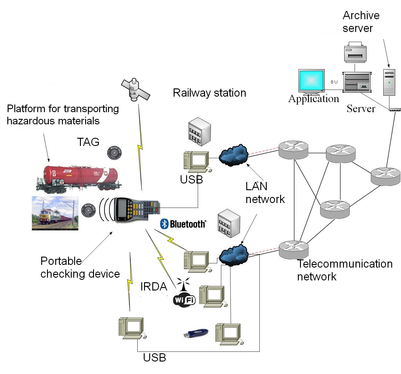
Fig. 1 A general structure of the system.
Basic functions that can be executed by the system include:
- the recording of duty of rail cars by an electronic counter with an innovative power supply and reading system at every rail car (every wheel set),
- the facilitation of reports on the composition of rail cars by to a hand checking device that reads out data from the sensors,
- the aid of the logistic processes in the form of a data base that automatically generates various types of reports – optimised use of transport means and management of maintenance activities.
The CDC kilometre counter (Fig. 2) is a small electronic sensor which counts axle revolutions and allows for converting the information into kilometres when the information is being read out. The counter also measures temperature and keeps information on a given car. The information is read out and saved over radio by putting a dedicated portable terminal with a reader against the sensor.
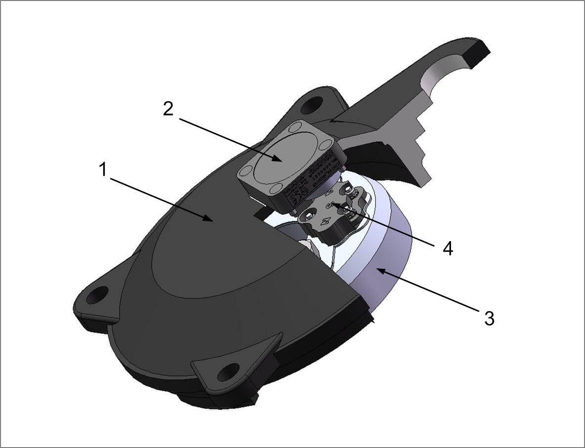
Fig. 2. An illustration of the device: 1) axle-box cover, 2) odometer, 3) rotating axle end, 4) magnetsMHD
The sensor is mounted on the axle-box cover.
The CDC device is not equipped with external electrical interfaces, buttons or displays (full containment). Both power supply and detection (counting of revolutions) is carried out by converting rotational motion of the magnets into ac current induced in the induction coil that supplies power to the counter (Fig. 2.). The coil is located inside the axle-box. A communication antenna (RFID) is located inside the counter, close to its outer surface.
Modules with magnets that mounted permanently on a specially modified plate for locking screws M20, screwed into the wheel set, are an integral part of the counter as its external component.
Summary
This paper aimed at introducing the problem of telematics in railway transport. Intentionally, the paper focused on projects that are less known in Poland to demonstrate that not only ERTMS, but also other solutions, are tested in Poland and worldwide. It was also intentional to omit information on ERTMS and GSM-R systems because this subject is discussed widely in many interesting papers and studies. The presented system for recording travelled route is an interesting example of telematics in practice. It seems that the CDC counter itself has not much to do with telematics, however, from the perspective of the entire system, such doubt vanishes. Moreover, it appears that there is no turning back from telematics in railway transport. Certainly, the term will not be used as it should be for a long period of time yet. However, with the benefit of hindsight, it may be concluded that the concept of telematics will become more popular in the Polish railways. Another problem is to decide when we do refer to telematics and when not.
____________________________________________________
Author: Jakub Młyńczak 1
1 Jakub Młyńczak, Silesian University of Technology, Faculty of Transport, Chair of Automatic Control Krasinskiego 8, 40-019 Katowice
___________________________________________________________________
References
[1] Białoń A., Gradowski P., Iwański R., “ERTMS Regional – the control command system proposal for low density lines”, Advances in Transport Systems Telematics, WKiŁ, Warsaw, 2008, pp. 25-32
[2] Mertens P., Franckart J-P., Starck A. “A Low-Cost Train Location and Signalling System for “Low Density” Lines”, WCRR, Edinburgh 2003
[3] Staton G., „INTEGRAIL Project Overview”, EGNOS/INTEGRAIL Demonstration, Guateng 2005
[4] Kayser – Threde: „Radio Compass Final Presentation”, ESTEC, Noordwijk, 2003
[5] Hejczyk T.: Telemetric system for track measurement in rails vehicles without electric power supply, Archives of Transport Systems Telematics, vol. 4, issue 4, November 2011.
[6] Mikulski J., Using telematics in transport, w „Transport Systems Telematics, Selected Papers”, Springer Verlag, CCIS 104, ISBN 978-642-16471-2, Berlin – Heidelberg, pp. 175-182 , 2010
